NovAtel PwrPak7 GNSS Receiver Enclosure
Rugged all-constellation OEM7 receiver enclosure with GRIT interference and spoofing detection for reference and monitoring stations
The PwrPak7 is Hexagon | NovAtel's compact, rugged receiver enclosure built around the OEM7700 GNSS engine - a turnkey way to field NovAtel's high-precision tracking and GRIT interference-monitoring firmware without board-level integration. It tracks all current and upcoming constellations and signals: GPS (L1 C/A, L1C, L2C, L2P, L5), GLONASS, Galileo (E1, E5 AltBOC, E5a, E5b, E6), BeiDou (B1I, B1C, B2I, B2a, B2b, B3I), QZSS, NavIC and SBAS, plus up to five L-Band channels for TerraStar corrections - and is software-upgradeable in the field as new signals come online. For aviation-infrastructure buyers the headline is resilience: spoofing detection, interference detection and mitigation are provided by NovAtel's GNSS Resilience and Integrity Technology (GRIT), so a PwrPak7 on a rooftop or airfield mast becomes a continuously watching interference-monitoring station, with the free GRIT Monitor dashboard providing spectrum, waterfall, signal-matrix and map visualisation.
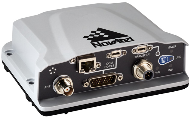
Positioning scales from 1.5 m single-point to 1 cm + 1 ppm RTK and 2 cm TerraStar-X PPP, with <5 ns RMS time accuracy and up to 100 Hz measurement and position output. Connectivity is comprehensive for a 500 g, 147 x 125 x 55 mm unit: three serial ports, USB host and device, 10/100 Ethernet with onboard NTRIP client/server and web GUI, CAN, built-in Wi-Fi, PPS output, event I/O and Precision Time Protocol (PTP) support, plus 16 GB of internal storage for logging spectrum and observation data on site. The enclosure is genuinely field-hardened: IP67-rated, -40 C to +75 C operating, tested to MIL-STD-810H for vibration (Cat 24, 20 g RMS), shock (40 g) and acceleration (16 g), while drawing 3.25 W typical from a 9-36 VDC supply.
SPAN GNSS+INS variants (PwrPak7-E1/E2 and dual-antenna PwrPak7D versions) add an internal IMU interface to bridge GNSS outages for vehicle-mounted interference mapping or airside survey work. FCC, ISED, CE and global type approvals are held, and hardware variants without Wi-Fi or internal storage are available.
Technical specifications.
| Signal tracking | GPS L1 C/A, L1C, L2C, L2P, L5; GLONASS L1 C/A, L2 C/A, L2P, L3, L5; Galileo E1, E5 AltBOC, E5a, E5b, E6; BeiDou B1I, B1C, B2I, B2a, B2b, B3I; QZSS L1 C/A, L1C, L1S, L2C, L5, L6; NavIC L5; SBAS L1/L5; up to 5 L-Band channels |
| GNSS resilience | spoofing detection, interference detection and mitigation provided by GRIT (GNSS Resilience and Integrity Technology) |
| Horizontal position accuracy (RMS) | 1.5 m single point L1; 1.2 m single point L1/L2; 40 cm DGPS; RTK 1 cm + 1 ppm; TerraStar-X 2 cm (subscription) |
| Time accuracy | <5 ns RMS; velocity accuracy <0.03 m/s RMS; data rate up to 100 Hz (measurements and position) |
| Time to first fix | cold start <34 s (typ), hot start <20 s (typ); signal reacquisition L1 <0.5 s, L2 <1.0 s (typ) |
| Onboard | OEM7700 GNSS engine, 16 GB internal storage, NTRIP v1.0/v2.0 client and server, Precision Time Protocol (PTP), web GUI |
| Physical | 147 x 125 x 55 mm, 500 g; TNC antenna, RJ45 Ethernet, DSUB HD26 serial/CAN/event I/O, M12 power connectors |
| SPAN GNSS+INS ready | interfaces with supported IMUs to bridge GNSS outages (PwrPak7-E1/E2 variants with internal IMU) |
| Interfaces | 3x RS-232 (2 selectable RS-422) up to 460,800 bps, USB 2.0 host + device, 10/100 Ethernet, CAN 1 Mbps, built-in Wi-Fi, 3 event inputs, 3 event outputs, 1 PPS output, quadrature wheel-sensor input |
| Power | +9 to +36 VDC input, 3.25 W typical consumption; antenna LNA output 5 VDC +/-5%, 200 mA max |
| Environmental | -40 C to +75 C operating, IP67, 95% non-condensing humidity; MIL-STD-810H vibration (Cat 24, 20 g RMS), shock (40 g), acceleration (16 g); IEC 60068-2-6 / 60068-2-27 |
Available variants.
Certifications.
Use cases.
- ›GNSS interference and spoofing monitoring station at airports (paired with GRIT Monitor dashboard)
- ›Base station / reference receiver for airport survey, GBAS siting and construction positioning
- ›Precise timing source with PTP for ATC, airport IT and telecom infrastructure
- ›Continuous RF spectrum logging (16 GB onboard) for aerodrome interference investigations
- ›Vehicle-mounted interference mapping around runway protection zones (SPAN INS variants)
- ›UAV and ground-vehicle navigation in interference-challenged environments