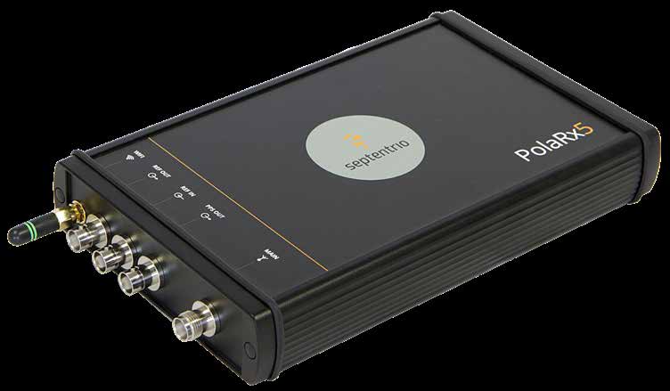
Septentrio PolaRx5 Multi-frequency GNSS Reference Receiver
Best-in-class 544-channel GNSS reference receiver with AIM+ interference monitoring, spoofing detection and OSNMA for permanent monitoring stations
The PolaRx5 is Septentrio's flagship multi-frequency GNSS reference receiver, deployed in continuously operating reference station (CORS) networks worldwide — including the EarthScope/UNAVCO Plate Boundary Observatory — and the natural choice where an airport, ANSP or national network operator needs a permanent, high-integrity GNSS monitoring station. Its 544 hardware channels track all visible signals from GPS, GLONASS, Galileo, BeiDou, NavIC, QZSS and SBAS, with P-code tracking on L1/L2 to avoid C/A-P biases, independent L2C tracking, and raw data output at up to 100 Hz. In independent competitive testing the PolaRx5 produced the lowest number of cycle slips with best-in-class measurement quality: 1–1.3 mm carrier-phase precision on all signals and unsmoothed pseudorange precision down to 1.5 cm on Galileo E5 AltBOC.
Signal integrity is protected by Septentrio's GNSS+ technology stack. AIM+, the Advanced Interference Monitoring and Mitigation system, continuously watches the RF spectrum through an integrated spectrum analyser and flags and mitigates narrowband and wideband interference, jamming and spoofing — from simple continuous carriers to complex pulsed transmitters and chirp jammers. Galileo OSNMA authentication support adds cryptographic protection against spoofed navigation data. APME+ eliminates short-delay multipath without introducing bias, and LOCK+ keeps tracking robust through vibration and rapid signal dynamics such as scintillation events. That combination makes the PolaRx5 a monitoring-grade sensor for airport GNSS environments where jamming or spoofing near approach paths is an operational risk and every event needs to be captured and characterised.
Operationally the receiver is built for unattended networks: 1.8–4.7 W scalable power consumption, 9–30 VDC input or Power-over-Ethernet, integrated Wi-Fi, secured web UI, NTRIP caster/client/server, optional RTK/DGNSS corrections, and 16 GB onboard logging in SBF, RINEX, BINEX, RTCM MSM, CMR and NMEA with up to 40 parallel logging jobs. SYNC+ smart telemetry retransmits only missing file fragments, minimising bandwidth over constrained links. The IP65-rated aluminium housing measures 235 × 140 × 37 mm, weighs 0.9 kg and operates from −40 °C to +65 °C.
Technical specifications.
| Hardware channels | 544 |
| Constellations tracked | GPS (incl. P-code L1/L2, L2C, L1C, L5), GLONASS (L1, L2, L3), Galileo (E1, E5a, E5b, E5 AltBOC, E6), BeiDou (B1I, B1C, B2I, B2a, B2b, B3I), NavIC L5, QZSS, SBAS |
| Interference monitoring | AIM+ monitors, flags and mitigates narrowband and wideband interference, jamming and spoofing; integrated spectrum analyser |
| Anti-spoofing | Galileo OSNMA support; spoofing detection and flagging via AIM+ |
| Multipath / tracking robustness | APME+ a-posteriori multipath estimator (code + phase); LOCK+ tracking under shocks and scintillation |
| Carrier phase precision (all signals) | 1–1.3 mm |
| Pseudorange precision (unsmoothed) | 1.5 cm (E5 AltBOC) to 25 cm (GLONASS L1 C/A) |
| Static precision (RMS, horizontal) | 3 mm + 0.5 ppm |
| Max raw data rate | 100 Hz |
| Time accuracy (1PPS out) | 5 ns |
| Data formats | SBF, RINEX v2.x/3.05/4.00, BINEX, RTCM (all MSM), CMR 2.0, NMEA v2.30/v4.10 |
| Interfaces | 4 hi-speed serial, 100 Mbps Ethernet (PoE), Wi-Fi 802.11 b/g/n, USB device + USB host, 10 MHz REF IN/OUT, PPS out (max 100 Hz), HTTP/HTTPS, FTP/SFTP, NTRIP |
| Onboard logging | 16 GB, up to 40 logging jobs; SYNC+ smart telemetry |
| Input voltage | 9–30 VDC |
| Power consumption | 1.8–4.7 W |
| IP rating | IP65 |
| Operating temperature | −40 to +65 °C |
| Dimensions | 235 × 140 × 37 mm |
| Weight | 0.9 kg |
Available variants.
Certifications.
Use cases.
- ›Airport and ANSP permanent GNSS reference and monitoring stations
- ›GNSS interference, jamming and spoofing surveillance at aerodromes
- ›CORS network stations and RTK/DGNSS correction services
- ›Scientific and geodetic monitoring (deformation, seismic, ionospheric)